
The Earthworm Foundation co-developed Starling with Airbus to help companies monitor deforestation commitments with satellite imagery. Nestlé, Ferrero and Lindt are among the system’s users.
Rob McWilliam, director of technical services at Earthworm, told the podcast: “We basically mine the pixels to detect the land cover today and looking back 20 years.”
Users can create a base map featuring farms in their supply chain, their proximity to protected forests and can compare to satellite data on forest cover change.
This allows companies to make good on no deforestation commitment and take remedial action where forest clearing is suspected.
But the system is only at its full potential when companies know the farms supplying them.
No more secrets? Sharing data to stop deforestation
The satellite data works best in conjunction with maps of farms in a company supply chain, which are still collected on-the-ground.
Company farm boundary data is often collected by field agents working for suppliers that polygon map GPS coordinates of farm boundaries.
This is typically the farms within a company’s direct supply chain: i.e. the volumes under its company sustainability programme.
“In the past there hasn’t been a huge openness between companies, or even from companies to government to share plantation boundaries,” said McWilliam.
“But I think that dynamic is changing. Companies are increasingly willing to collaborate,” he said.
Earthworm is now in discussions to facilitate stronger collaboration via the Starling platform. Increased openness will help finetune the response to deforestation alerts, it hopes.
“I’d hate to see a company engaging on the ground to address a deforestation event or eliminate further encroachment and then another company using Starling would do the same thing,” said McWilliam. “That would be a significant waste of resources.”

Higher resolutions show agriculture under forest canopy
The Starling system is comprised of Airbus’ own satellites as well as publicly available mapping data from entities like the European Space Agency and NASA.
How accurate is satellite mapping?
Starling achieved 94% accuracy in detecting deforestation during tests in the Cavally forest of Côte d'Ivoire. According to Earthworm, modern satellites can also differentiate agroforestry from forest cover and cocoa from forest cover and other crops, but it is still challenging. “From space, you may not see a clear distinction and confusion can happen,” said McWilliam, adding ground truthing is still needed.
The newer 50cm satellite resolutions used in Starling can detect agricultural development under forest canopy, which wasn’t previously possible.
This for example allows Starling to detect cocoa growing in protected forest reserves in Côte d’Ivoire.
“If we were trying to do that 30 years ago, it would have been near impossible to detect that. We would have had to have much more presence on the ground,” said McWilliam.
Not yet real-time: Manageable quarterly updates
Starling’s satellite imagery is not real time. There is a time lag of between two and five days. But Earthworm suggests this makes the data more manageable.
“Companies were struggling to process the constant feeds of data and to respond with boots on the ground,” said McWilliam. Many companies are now looking for more manageable monthly or quarterly updates, he said.
Satellite data cannot alone halt deforestation, but it has already helped spot risks and prevented further encroachment.
For example, Starling had spotted a continuous trend of impoverished people moving from highly populated areas on outskirts of some forested areas in Côte d’Ivoire to grow cocoa in the forest, “making the best of the situation they are in,” said McWilliam.
Governments and companies have since been able to react to the imagery via joint platform the Cocoa & Forests Initiative.
Companies can react most effectively when they know the source of their cocoa – but most firms can’t pinpoint the exact farm for all their cocoa.
Most major players in chocolate have no deforestation commitments for cocoa, but can only trace so much to farm gate.
The chart below displays the ‘declared’ cocoa traceability globally of each company in 2018. The level of traceability (i.e. to Tier 1: Ingredients supplier; Tier 2: Cooperative or farmer group or Tier 3 Farmers) is often unreported and unknown, expect for Mars, which states its 24% traceability is to Tier 3.

In Côte d’Ivoire and Ghana, companies are getting GPS coordinates using mobile apps for their ‘direct’ supply chains, which are part of company sustainability programmes.
These cocoa farm locations can be used in conjunction with Starling’s forest cover maps.
Lumina estimates 49% of global cocoa used by the top six chocolate brands was procured according to company definitions of ‘sustainable cocoa’, which vary. We estimate 43% was procured ‘sustainably’ in 2018 by the big three suppliers.
Most - but not all – of these ‘sustainable’ volumes are being mapped.
But on average, the top nine players procure around half of cocoa volumes outside company programmes. These companies have many untraceable volumes and varying targets to attain 100% traceable cocoa.

Untraceable cocoa outside of company sustainability programmes is frequently purchased from local traders under the mass balance system. Côte d’Ivoire revised its forest code in 2019 to compel local traders to prove traceability from farm to first purchase - but McWilliam said he wasn't aware of any farm mapping yet taking place in the indirect supply chain.
Pinpointing future risks
Therefore, Starling could identify deforestation, but a company may not even know it’s bought cocoa from the offending farm.
“There’s definitely a risk of that,” said McWilliam.
He said traceability today was a linear process of identifying the suppliers of a company’s supplier to trace the cocoa to a farm. And even that is complicated by cocoa being mixed along the supply chain.
“Often that will yield that ‘no, none of the farms in protected areas are in your supply chain,” said McWilliam. “No one is going to self-declare that kind of information,” he said.
But he hoped satellite data could identify farms in the indirect supply chain within the vicinity of protected areas to detect potential future encroachment.
“That could aid efforts to target actions on the ground,” he said.
Lumina's podcast also asks:
- Is agroforestry akin to forest cover in carbon storage and biodiversity values?
- Can satellites mapping can identify forest restoration sites?
- Should companies should share farm boundary data to help combat deforestation?
Subscribe & listen on Apple Podcasts, Spotify, or your favourite podcast platform.
Update: Mighty Earth’s Cocoa Accountability Map
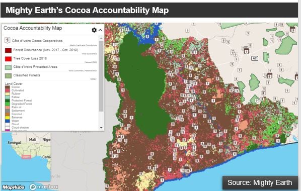
Campaign group Mighty Earth is planning to relaunch its Cocoa Accountability Map in the coming months. The initial map – using satellite data from the IMAGES platform, rather than Starling - features the locations of farmer cooperatives, their certifications, proximity to protected areas and the companies sold to, such as Nestlé or Lindt for a third of the Ivorian cocoa area. The updated version will cover land use across the country and will add cooperatives supplying Mars and Ecom. Cooperatives supplying Cargill, Mondelez and Lindt (cocoa butter supply) are also likely to feature, while Mighty Earth has erased duplicate coops.
Lumina Intelligence Sustainability's New Report -Halting cocoa-driven deforestation

Lumina Intelligence Sustainability - the insights platform for cocoa, coffee and tea sustainability from publisher William Reed - last week published the report 'Life on Land: Halting cocoa-driven deforestation'. Lumina analyses how far the chocolate and cocoa industry is going to halt deforestation by 2020 and to restore degraded land and soil by 2030 under United Nations Sustainable Development Goal 15: Life on Land. The report explores the strengths and pitfalls of the Cocoa & Forests Initiative (CFI) amid warnings of a climate emergency and an incoming living income differential (LID) in the top two cocoa-producing nations, as well as the prospects for blockchain and mobile technology. The report is available for purchase or can be viewed via an annual Lumina subscription. A subscription gives access to all reports, a company commitment database and interactive tools to measure consumer enagement with sustainable chocolate, coffee and tea across 20 countries. See HERE for FoodNavigator's summary of the report.


